Tales From the Terminals: Waterloo Station (Part 1)

Waterloo Station… the UK’s largest railway terminal.
Handling an average of over 90 million passengers a year, Waterloo which lies close to London’s South Bank, is the UK’s largest railway station.

Bird’s eye view of Waterloo Station displaying its proximity to the Thames (image: Google).
The origins of Waterloo Station stretch back to 1838 with the founding of the London and Southampton Railway, a company established to provide an important rail link between the capital and the docks at Southampton.
Detail from a London & Southampton Railway map, 1839.
Originally designed with freight in mind, the London end of the new connection to the south coast opened on 21st May 1838 at Nine Elms, an area close to a wharf on the southern shore of the Thames- some distance away from the present Waterloo station.

A very rural Nine Elms as it appeared in the 1830s.
Built in the neo-classical style, the station building at Nine Elms was designed by Sir William Tite, the same architect who designed the Royal Exchange which stands opposite the Bank of England.

Sir William Tite’s Nine Elms Station.
Although a convenient place for shifting cargo, the Nine Elms location proved to be most inconvenient for the growing numbers of passengers who were beginning to use the line for trips into London.
There were pleasure gardens at nearby Vauxhall which were a popular destination, but for those wishing to travel onwards to Westminster and the City things were a real hassle with trips having to be completed by boat (which involved a lengthy wait) or by road (which involved high costs due to the existence of turnpike tolls).

The former Vauxhall Pleasure Gardens- the only London landmark which was easily accessible from Nine Elms station (image: History Today).
As the London Illustrated News reported at the time, “the distance of the South Western’s metropolitan terminus from the heart of London has been a subject of complaint from the first opening of the line.”
Moving On
Realising that their railway fell short- and that there was of course more money to be made- the company (now renamed the London and South Western Railway) decided to extend the line approximately 2 miles north across Lambeth Marsh in a project costing £800,000- approximately £35 million in today’s money.

Map detailing the route of the extension from Nine Elms to Waterloo (image: Google).
The site marked for the new terminal was described as being “vacant ground, to a great extent occupied as hay-stalls and cow-yards and by dung-heaps, and similar nuisances” which lay close to the southern foot of the recently opened Waterloo Bridge.

Old Waterloo Bridge pictured in 1846 (image: Metropolitan Museum of Art)
A lost ‘Trafalgar Station’?
The station’s South Bank site was a plan B option- what developers had really wanted was to cross the Thames and build a station right opposite what was then a pretty much brand new Trafalgar Square.
The snag with this however was that the Duke of Northumberland’s mansion stood in the way and he refused to release the land… a 170 year old decision which still brings cabbies plenty of quick fares across the river during the rush hour!

Northumberland House pictured in 1753. Note the statue of Charles I (in the bottom right hand corner) which remains in the same position today. The mansion was demolished in 1874 and is now covered by Northumberland Avenue.
Had the site been allowed it is quite possible that the LSWR’s terminal would have been named ‘Trafalgar Station‘… either way, a name in honor of one of the great victories of the Napoleonic Wars was inevitable!

The station that never was… if plans had come to fruition, the LSWR’s terminal would have stood right opposite Trafalgar Square.
Bridging the Bogs
In order to traverse the boggy ground the extension required the construction of a brick viaduct comprising 290 arches- very similar to the London and Greenwich Railway which was constructed on the opposite side of the capital during the same era.

Images of the Nine Elms to Waterloo arches from 1840 (top image- ‘Church Street’- now Lambeth Road. Bottom image- Westminster Bridge Road. (Images: London Illustrated News).
Whilst building the viaduct from Nine Elms to Waterloo the tradesmen certainly didn’t hang around. The arch across Miles Street for example is said to have taken just 45 hours to complete from scratch, despite being at a tricky angle and requiring some 90,000 bricks!

Miles Street arch… built from scratch in less than three days! (Image: Google)
The LSWR turned again to Sir William Tite to design their new terminal and, like the track extension, the station had to be built upon a series of arches in order to rise above the soggy earth; a high-rise position which is still evident to this day.

A very early view of Waterloo Station as pictured in the 1840s (image: London Illustrated News).
I wonder how many of the passengers in my cab who asked to be dropped at “Waterloo steps” realise why they have to huff and puff up such a steep flight in order to catch their train….

The slope outside Waterloo’s main entrance indicates the height at which the station was built.
Named ‘Waterloo Bridge Station’, the new terminal, with a 600ft façade facing York Road, opened to the public on the 11th July 1848 with just three platforms and 14 trains a day.

York Road today- The site of Waterloo’s original facade is now occupied by late 20th century office blocks (image: Google).
Originally, the station was never intended to be the end of the line- it was planned that the rails would be forged onwards, right into the heart of the financial square mile.
As we can see today of course, this vision was never realised (with the exception of an underground link which we will come to later) and the site was officially renamed ‘Waterloo Station’ in 1886.
*
The Decline of Nine Elms
With the opening of the Waterloo terminal, the original Nine Elms Station closed to passengers in 1848.
A vast freight yard and wagon works flourished on the site but suffered heavy damage during WWII from which it never fully recovered. A clip of the site as it appeared in the mid-1960s, during the last days of steam, can be seen below (please click to view).
In the early 1950s, it was proposed that Tite’s surviving Nine Elms station building would make an ideal home for a planned National Railway Museum. However, British Rail refused to release the land and the museum eventually found a very worthy home in the beautiful city of York.

Photograph of the now long lost Nine Elms station.
The Nine Elms building was sadly demolished in the 1960s, paving the way for the construction of New Covent Garden Market which still occupies the site today, maintaining the location’s historical link as a major hub for shifting goods into the capital.

New Covent Garden Market (image: Wikipedia).
In a few years’ time, the area will also provide a home for the new American Embassy.

Looking towards Nine Elms today (image: Google).
*
Back at Waterloo
With the addition of connections to different railway companies, Waterloo station expanded in a messy, chaotic way throughout the Victorian period.
As new platforms were added they gained eccentric nicknames such as ‘Cyprus Station’ and ‘Khartoum Station’; each with their own entrance, booking office and Hackney Carriage rank.

Waterloo Station in 1902.
Some platform numbers were duplicated whilst others weren’t labelled at all which created considerable confusion. In 1889, this bizarre situation was satirized by Jerome K. Jerome in ‘Three Men in a Boat’:
“We got to Waterloo at eleven and asked where the eleven-five started from. Of course, nobody knew; nobody at Waterloo ever does know where a train is going to start from, or where a train when it does start is going to… the porter who took our things thought it would go from number two platform, while another porter, with whom he discussed the question, had heard a rumour that it would go from number one. The station-master on the other hand, was convinced it would start from the local.”
There was even a set of tracks which cut right through the pedestrian concourse and out through an arch towards what is now Waterloo East station.

Tracks heading onto Waterloo’s pedestrian concourse (image: London Reconnections).
Even by Victorian standards this rail link was a health and safety nightmare and was rarely used.
However, this curious set-up was still prominent enough to feature in H.G Wells’ 1898 classic, ‘War of the Worlds’ in a scene which describes troops departing Waterloo for Surrey in preparation for a clash with the Martian invaders.
“About five o’clock the gathering crowd in the station was immensely excited by the opening of the line of communication between the South-Eastern and South-Western stations, and the passage of carriage-trucks bearing huge guns and carriages crammed with soldiers.
These were the guns that were brought up from Woolwich and Chatham to cover Kingston. There was an exchange of pleasantries: ‘You’ll get eaten!’ ‘We’re the beast-tamers!” and so forth.”

Troops waiting to depart Waterloo on the eve of WWI, August 1914 (image: London Illustrated News).
The unusual bridge which linked the two stations is still in place and can be seen stretching over Waterloo Road.

The connecting bridge today, dormant over Waterloo Road.
Until relatively recently, it was used as a pedestrian link before being replaced by a more modern walkway (the grey, tube structure which can be seen running above).
TO BE CONTINUED…
Cabbie’s Curios: A Victorian Thirst Quencher
If you ever find yourself feeling thirsty within London’s historic square mile then head for St Paul’s churchyard where, standing opposite the southern side of the magnificent cathedral, you’ll find this equally monumental structure:
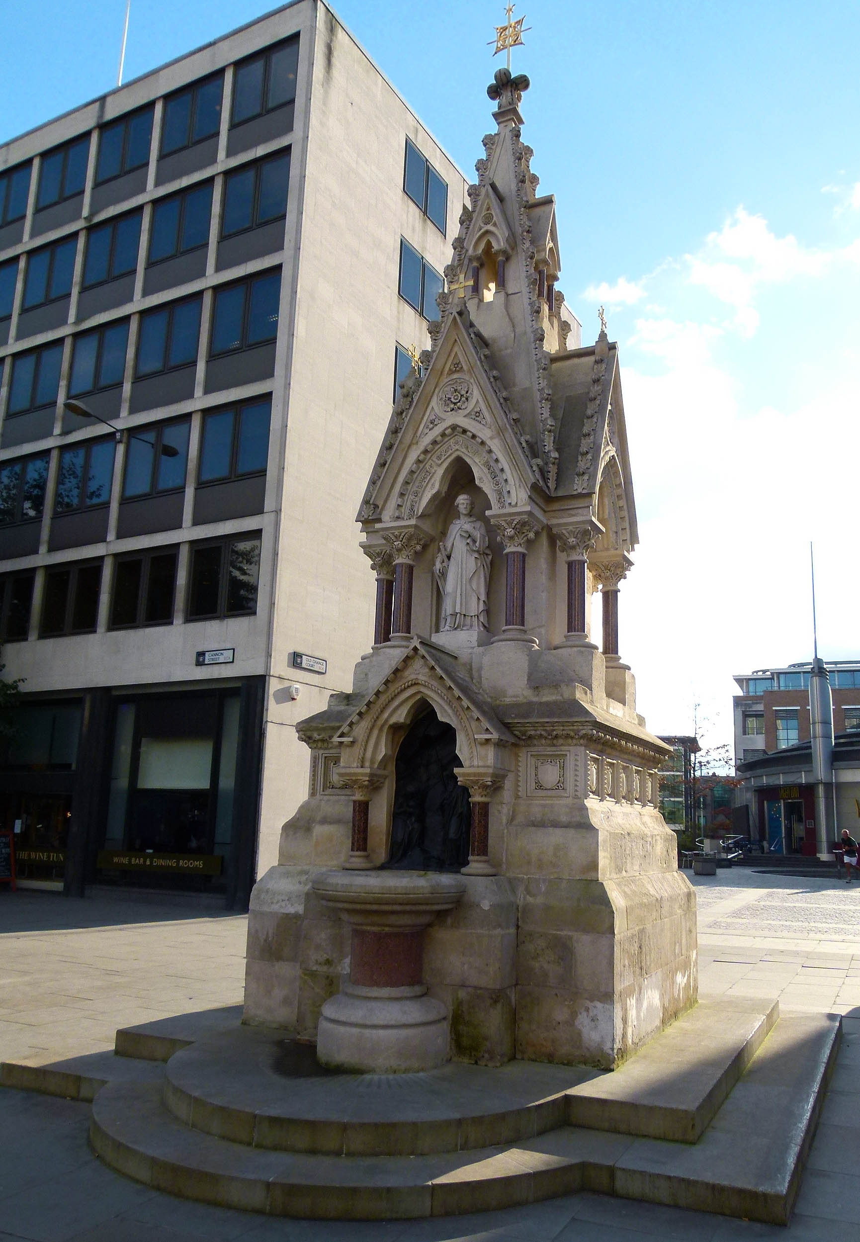
This is the St Lawrence Jewry Memorial Fountain which dates back to 1866. It has not always been at this site- its first home was a short distance away in the courtyard of St Lawrence Jewry church, Guildhall.

The fountain at its original location in the Guildhall courtyard.
The original St Lawrence Jewry church was one of many destroyed during the Great Fire of London in 1666.
It was rebuilt by Sir Christopher Wren and the fountain was installed 200 years later by the Victorians as a way of marking the bicentenary.

Close ups of the fountain’s religious detailing.
On the night of December 29th 1940 the church suffered appalling damage during what would turn out to be the heaviest night of the blitz.

The ruins of St Lawrence Jewry following the devastating December 1940 raid.
Amazingly the fountain survived, standing proud in the midst of the bombsite and holding the fort until the 1950s when St Lawrence Jewry was skilfully restored to Wren’s original design.

St Lawrence Jewry church today…. now thankfully fully restored (image: Wikipedia).
In the 1970s the Guildhall underwent extensive redevelopment which required the fountain to be dismantled.
Divided into 150 pieces, the Victorian masterpiece was reduced to a complex jigsaw, stashed away on pallets and stored at a barn in Epping where it would remain hidden for four decades.

The Guildhall Fountain in its original Victorian form…. (image: London Illustrated News).
The fountain finally returned to the streets of London in 2010 when it was lovingly pieced back together and installed at its new home opposite St Paul’s Cathedral; that other great survivor of the December 29th air-raid.

The iconic image of St Paul’s Cathedral, photographed on the night of December 29th 1940.
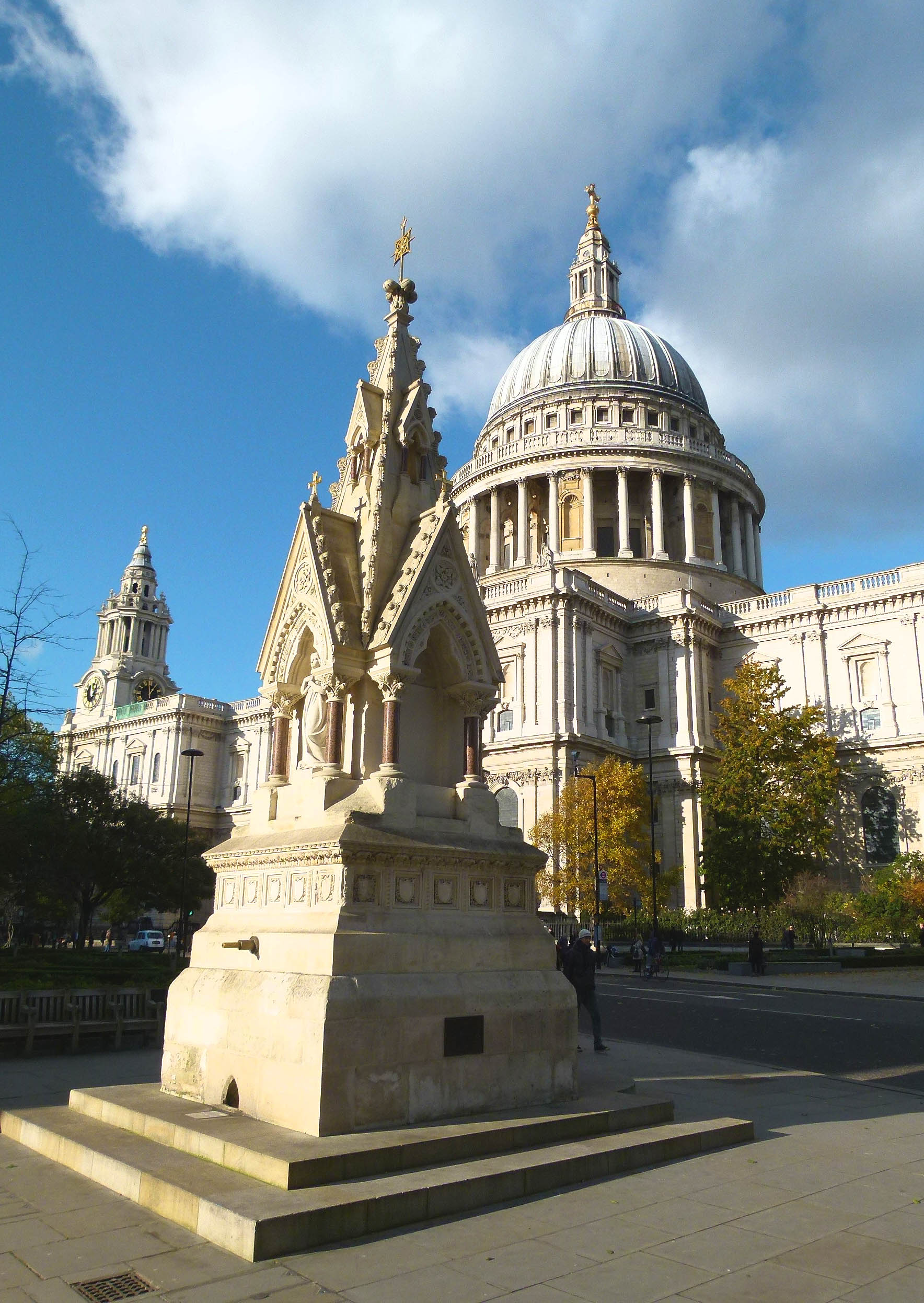
Two survivors together… St Paul’s Cathedral & the St Lawrence Jewry Fountain.
If you fancy a sip from the fountain, the pipe can be found around the back; on the south side which faces towards Distaff Lane and the Millennium Bridge.

A cyclist fills up from the Victorian fountain- the pipe is ideal for topping up water bottles.
Cabbie’s Curios : Covent Garden’s Cramped Alley
Pictured below is the London Coliseum (home to the English National Opera), which is located on St Martin’s Lane, Covent Garden.
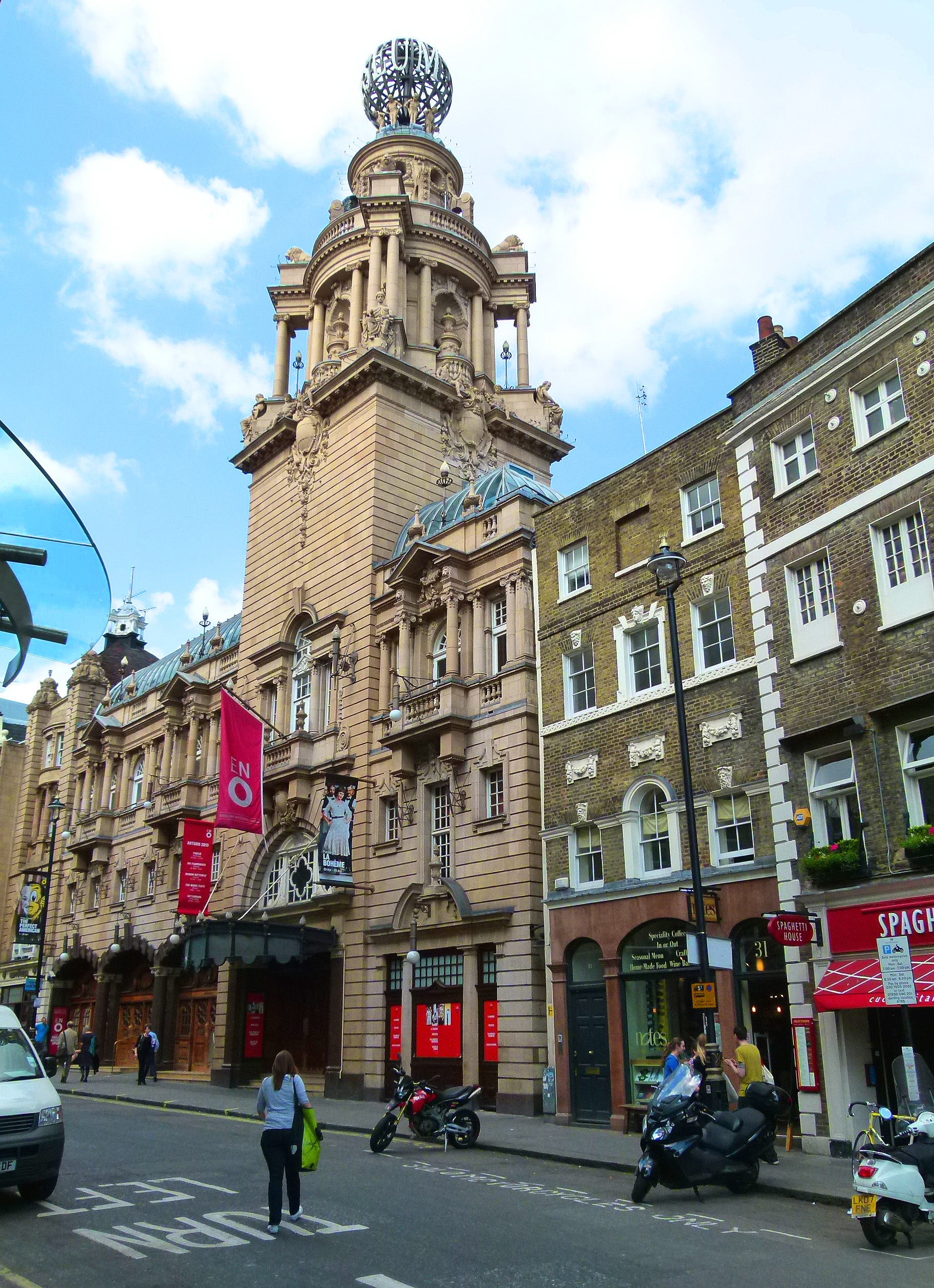
Did you notice the hidden alleyway?…

Location of the diminutive alleyway…
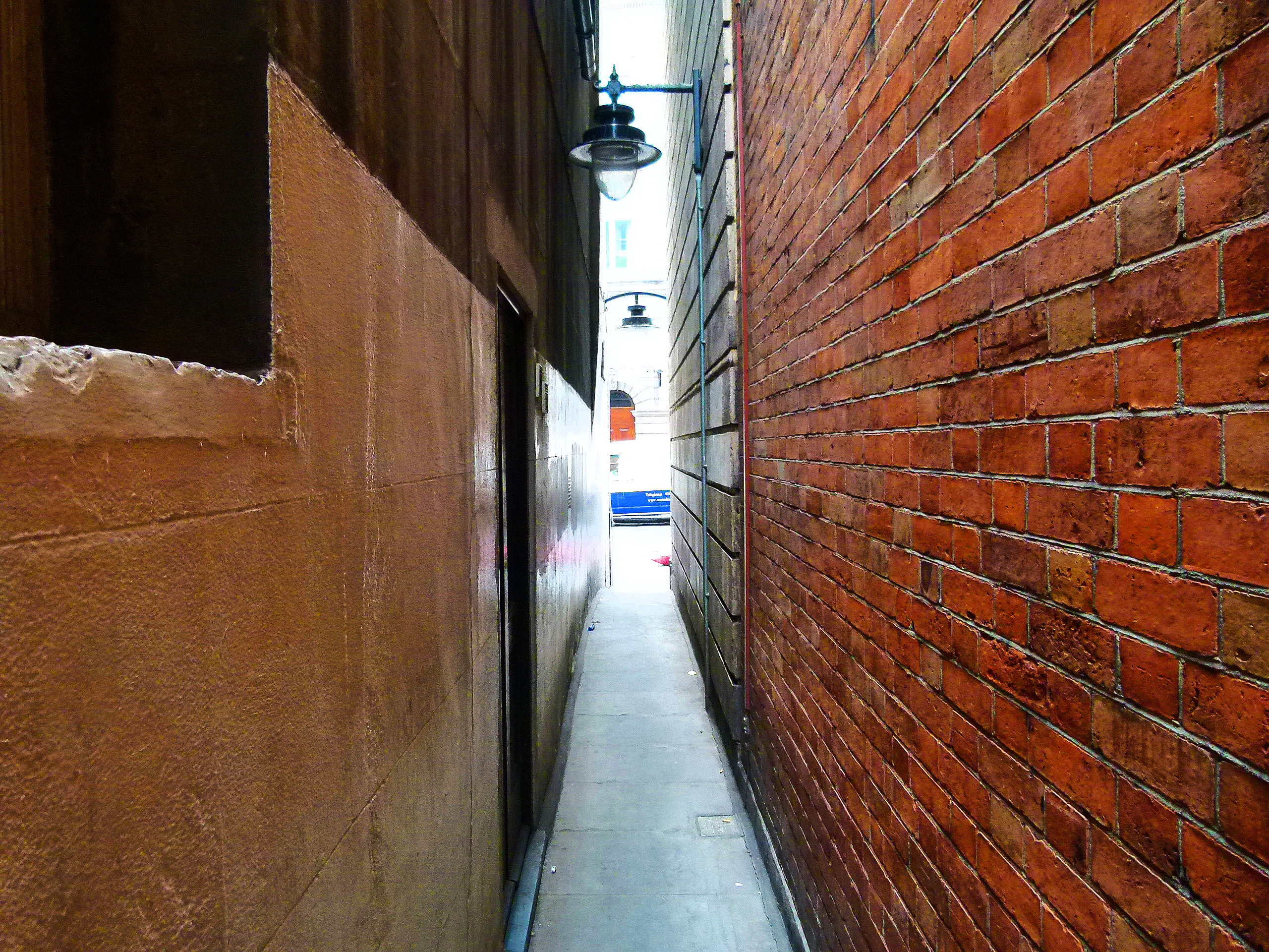
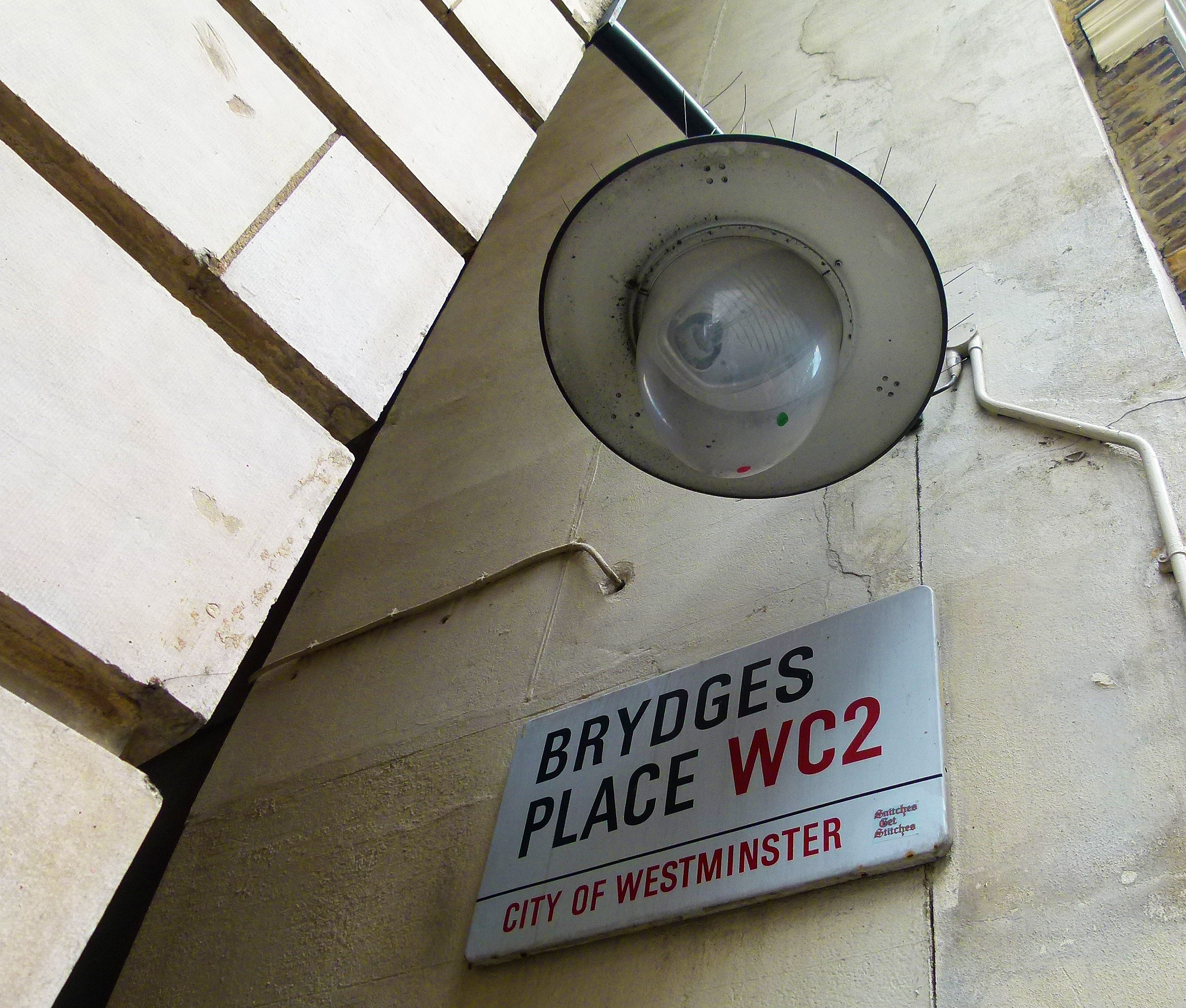
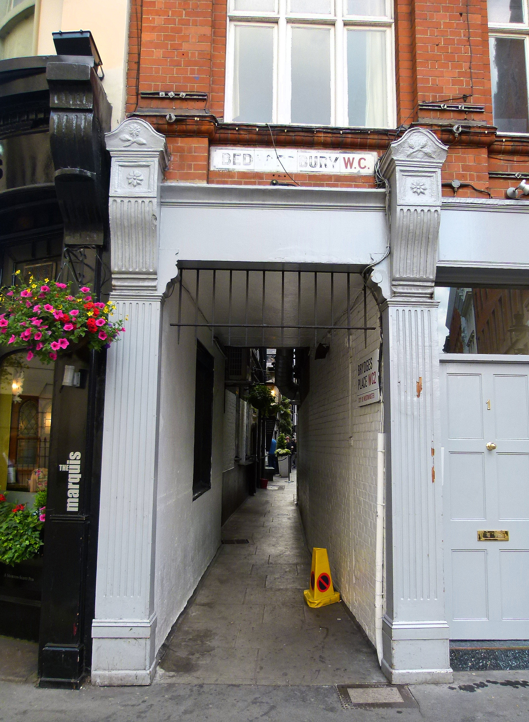
Running for approximately 250 ft. this secretive passageway is called ‘Brydges Place’ and provides pedestrians in the know with a quick link between St Martin’s Lane and Bedfordbury (just behind Charing Cross Police Station).

Brydges Place – St Martin’s Lane entrance.
At its tightest point, Brydges Place is just 15 inches wide, making it London’s narrowest alley- so is best avoided if you suffer from claustrophobia.
Brydges Place is named after Catherine Brydges of Chandos who married the fourth earl of the Bedford Family in 1608 (the Bedford family being the original owners of the land occupied by Covent Garden).
The Bedford dynasty gave their name to a number of streets in Covent Garden and, at one time, part of Catherine Street (home to the Duchess Theatre and the Theatre Royal) was known as Brydges Street.
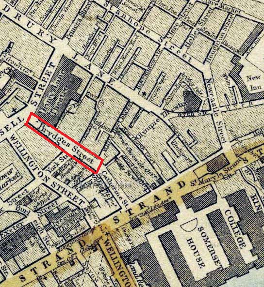
Brydges Street (now entirely named Catherine Street) on a map from 1868 (image: mapco.net)
Brydges Place as it stands today was created at the turn of the 20th century when the London Coliseum- which provides much of the alley’s northern wall- opened on Christmas Eve 1904.

However, a passageway covering this ground is nothing new- an alley had existed on the site long before its present incarnation and was known as ‘Turners Court’ before morphing into Brydges Place.
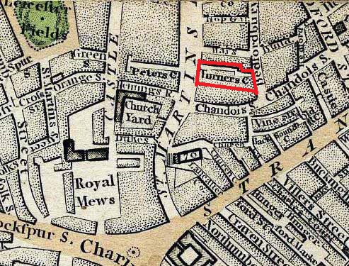
Turners Court…. note; the area labelled ‘Royal Mews’ in the bottom left hand corner of the map is now covered by the National Gallery.
On 15th August 1885, The Times carried a sad report on Mr Dennis O’Malley, a 73 year old sandwich-board man who lived and died in a tiny home on Turners Court.

A narrow window looking out on Brydges Place.
The flat- which Dennis O’Malley shared with his son- was described as a “front room in the basement” of a house into which another 14 people were crammed.
Mr O’Malley was “found lying dead on a kind of bed on the floor. The stench of the room was abominable.”

Dr Samuel Mills, who was called to the scene, stated that “he was not aware that such a place in Bedfordbury existed”…
Brydges Place Bedfordbury exit.
*
Today, the only active premise to be found tucked away on Brydges Place is the aptly named ‘Two Brydges Place’; a discreetly private club popular with those who work in the theatre and media (Simon Callow is a noted member).

A group of drinkers gather outside Two Brydges Place.
Two Brydges Place was established in the early 1980s by Rod Lane, an entrepreneur who founded the club on “the basis that I didn’t like going to places where people clicked their fingers at the waiters.”
Sounds like my kind of place!