Secrets of the Viaducts: Walking the London Bridge to Greenwich Arches (Part Two)
 This is part two in a series examining the history on and around the arches of the London and Greenwich Railway which was constructed in the 1830s.
To read part one, please click here.
This is part two in a series examining the history on and around the arches of the London and Greenwich Railway which was constructed in the 1830s.
To read part one, please click here.
* * *
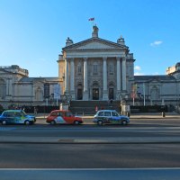
London Bridge
The viaduct to Greenwich begins its journey from London Bridge station; a terminal which is currently undergoing a major revamp beneath the shadow of The Shard– Western Europe’s tallest building.

Looking up at The Shard from London Bridge Station.
Since Roman times there have been many different versions of London Bridge, all of which have stood on the same spot, give or take a few feet. To read a previous post on the history of London Bridge, please click here.
When the London and Greenwich Railway opened in 1836, the bridge after which its terminal was named would have been the version built by John Rennie and, having been completed in 1831, would have been pretty much brand new at the time.

John Rennie’s London Bridge, seen from the direction of London Bridge Station. (Image: Victorian web)
Rennie’s bridge was replaced by today’s more utilitarian version in 1971… the original having been relocated to Lake Havasu in Arizona, USA after being purchased as the world’s largest antique by oil tycoon, Robert P. McCulloch.
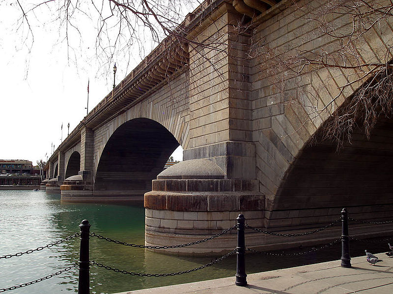
John Rennie’s London Bridge as it now stands in Arizona… (image: Wikipedia).
Stainer Street
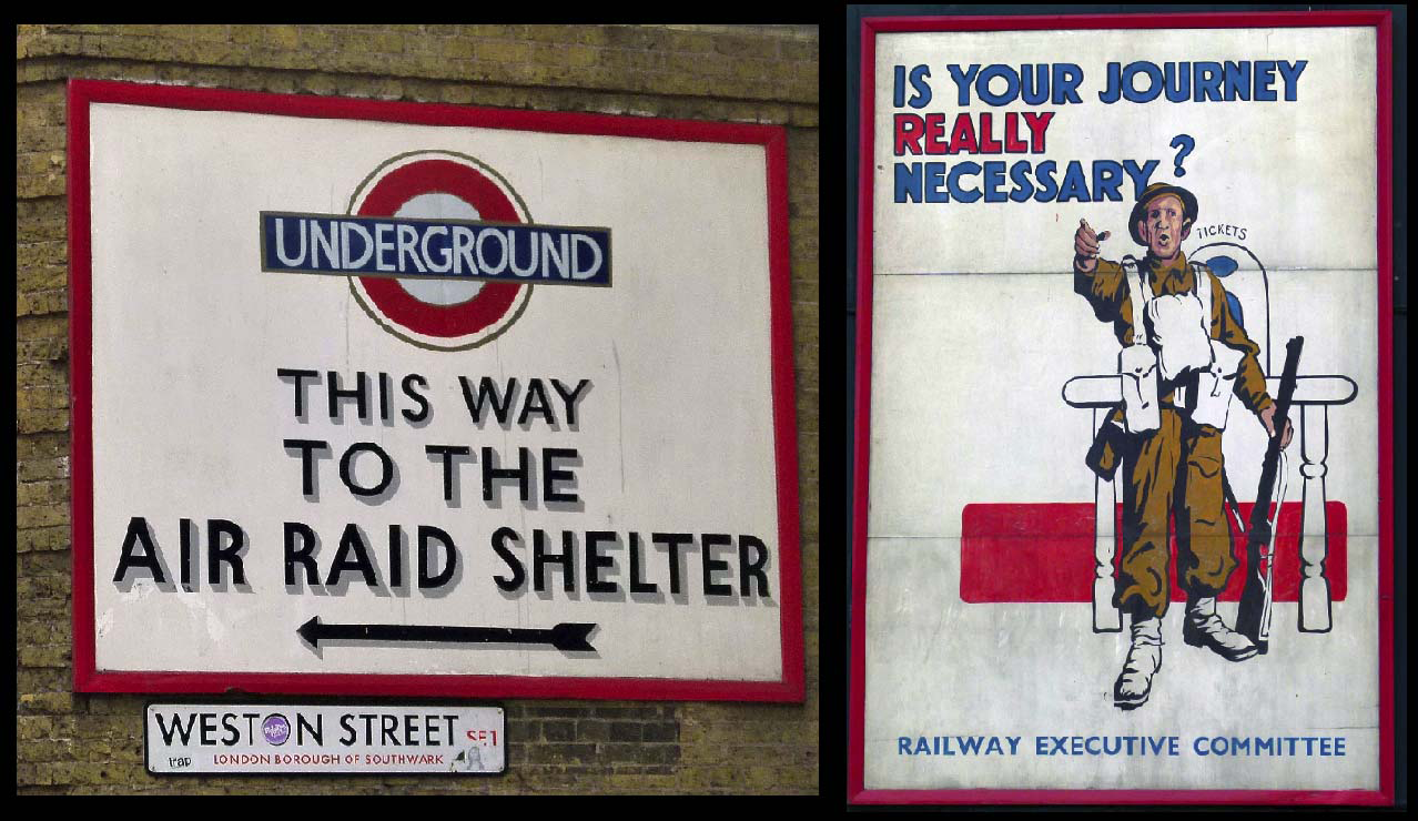
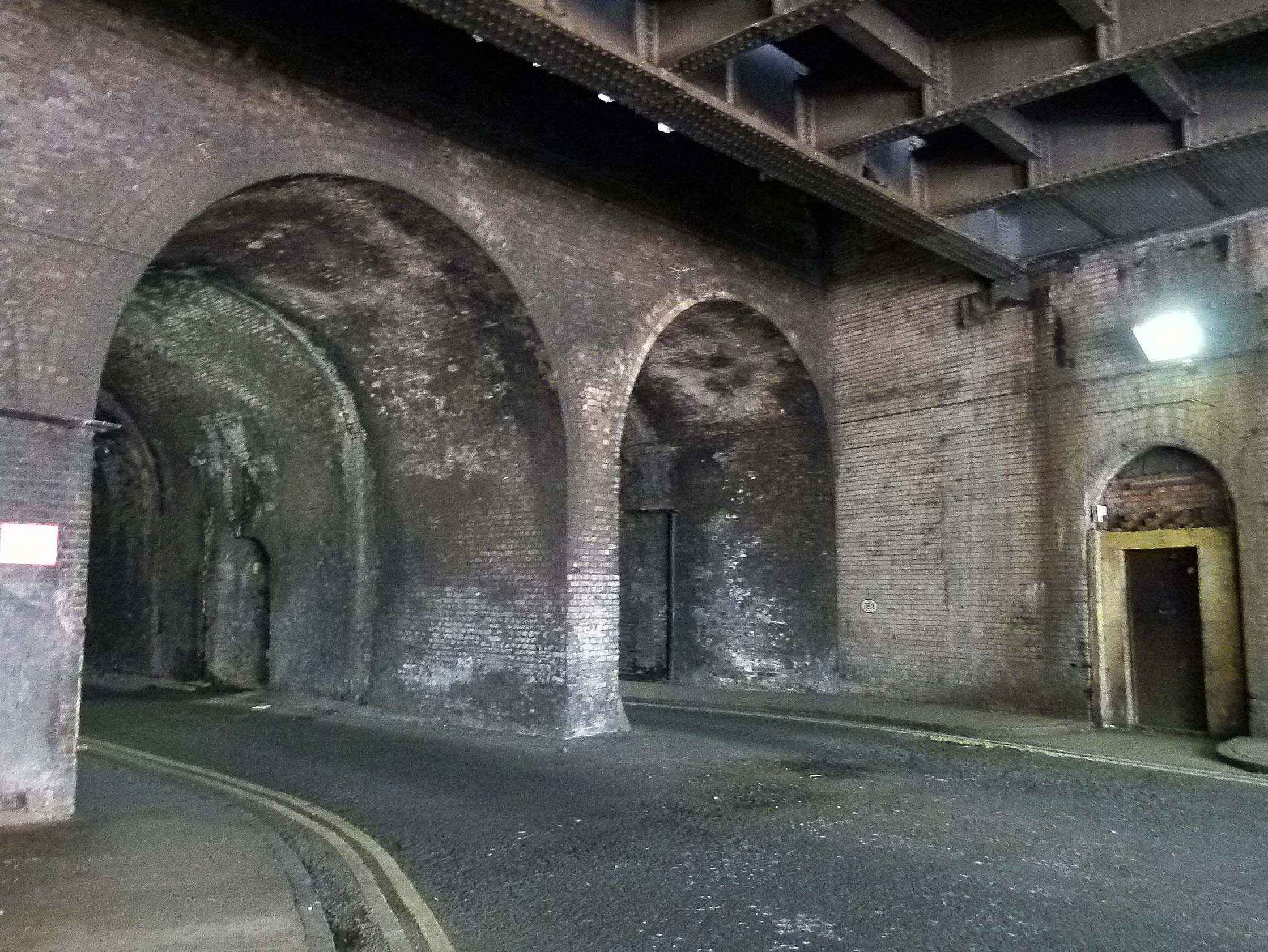
Dank with atmosphere, Stainer Street runs through a long tunnel beneath London Bridge Station.

Driving through Stainer Street… (image: Google Streetview).
During WWII, this cavernous area was employed as an air raid shelter for Londoners seeking protection during the nightly Blitz.
Tragically, on the evening of the 17th February 1941, catastrophe came to Stainer Street when the long arch suffered a direct hit, killing 68 people and injuring a further 178. Many of the casualties were medical staff from nearby Guys Hospital, who had rushed to the scene to help- only to be struck by a second explosion.

Aftermath of the Stainer Street bombing, 1941.
A large number of the fatalities were inflicted by the shelter’s steel blast doors which, weighing 10 tonnes a piece, had been installed at both ends of the tunnel. Blown towards those they were supposed to protect, their sheer weight proved lethal and so dense was the subsequent rubble, it is believed a number of the dead were never recovered and lie buried beneath Stainer Street to this day.
Two Saints
Heading out of London Bridge station, the viaduct is sandwiched between St Thomas Street and Tooley Street.

St Thomas Street
St Thomas Street owes its name to the infamous Saint Thomas Becket who was Archbishop of Canterbury from 1162 until 1170.
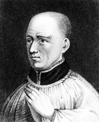
Saint Thomas Becket.
Born just across the Thames in Cheapside (near St Paul’s Cathedral), Becket went on to become a talented diplomat whose popularity blessed him with formidable clout when representing the church in disagreements with the king.
Unfortunately, Becket’s aptitude would prove to be his downfall.
On December 29th 1170, he was murdered inside Canterbury Cathedral by four knights who, according to legend, had taken their lethal action after supposedly overhearing King Henry II utter the immortal words, “who will rid me of this turbulent priest?”
Thomas Becket was made a saint just three years after his violent death and quickly became a beloved cult figure, inspiring thousands of medieval pilgrims to walk to Canterbury Cathedral where they would pay homage to the great man’s shrine.
At Canterbury, pilgrims could purchase a badge to commemorate their journey- one of the earliest examples of souvenirs being mass produced.
A pilgrim badge from Canterbury.
For those heading from London, the route to Canterbury would begin close to London Bridge on what is now Borough High Street, following the same trajectory as today’s train line to Greenwich. The trek from London to Canterbury was famously immortalised in Chaucer’s 14th century work, The Canterbury Tales.
*
If you Glimpse above the point where St Thomas Street crosses Bermondsey Street, you’ll spot the London Bridge Signal Box jutting out over the viaduct.

London Bridge Signal Box.
Employing 56 signallers, this unassuming control centre has the stressful task of overseeing the movements of over 2250 trains every weekday… that’s a lot of commuters to look after!
*
Tooley Street

Tooley Street.
‘Tooley’ is a rather convoluted corruption of ‘St Olave’; the name of a church which once stood opposite the northern edge of London Bridge station.

St Olave’s Church (image: London Ancestor.com)
The church was demolished in 1926; the site now occupied by ‘St Olaf House’; one of London’s finest examples of Art Deco architecture.

St Olaf House (constructed between 1928-32. Image: Google Streetview).
Saint Olaf II was an 11th century Norwegian king who encouraged his people to embrace Christianity rather than pursue the chaotic Viking ways and, probably due to Londoners struggling with Scandinavian pronunciations, it was his name which morphed into ‘Saint Olave’ and then ‘Tooley’.

Saint Olaf.
*
On June 22nd 1861, a huge fire broke out on Tooley Street’s Cotton’s Wharf in what would become the worst inferno to strike the capital since the Great Fire of London.

Contemporary painting depicting the Tooley Street Fire.
The blaze raged for two weeks and claimed the life of James Braidwood; the highly respected Scottish firefighter who’d founded the world’s first municipal fire service in Edinburgh; the success of which had led to him being appointed the London Fire Brigade’s very first director.

James Braidwood; the London Fire Brigade’s first director who died on Tooley Street in the line of duty.
*
Until recently, one of the first arches on Tooley Street was occupied by The London Dungeon, a popular tourist attraction which first opened in 1975.
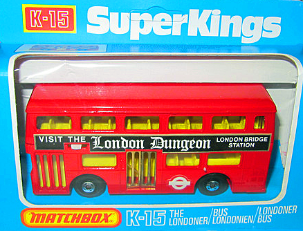
A toy bus from the late 1970s, advertising the then recently opened London attraction.
The dungeon’s suitably dank and dingy home beneath London Bridge station had originally been used as a storage facility for goods brought in via the Thames, where they would be stashed away before being hauled up to the rail network for further distribution across the country.
At first, the London Dungeon was essentially a waxwork emporium depicting London’s most notorious historical figures and brutal torture devices.
Personally speaking, I visited the attraction as a youngster; my abiding memory being that of an unfortunate mannequin, howling as he was slowly and repeatedly prodded into a giant cooking pot.
Over the years, the London Dungeon has morphed into something of a macabre theme park, complete with rides and actors. It vacated the original Tooley Street location in January 2013 and is now based in London’s County Hall.
Remnants from the original Dungeon however can still be seen below London Bridge Station…
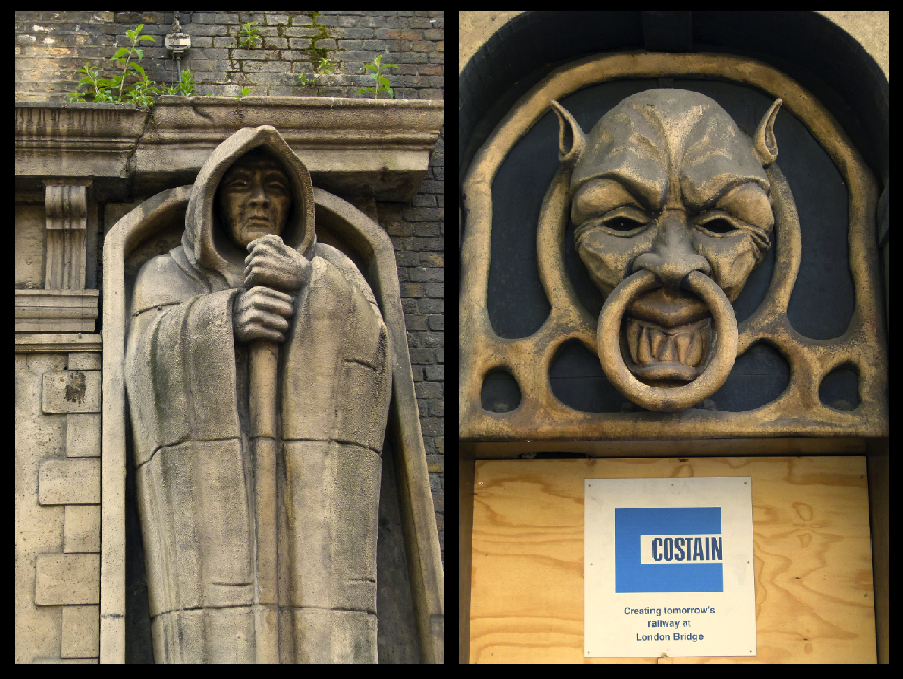
Remnants from the London Dungeon….
*
A little further along Tooley Street stand the original head quarters of the South Eastern Railway. Sadly, due to the major redevelopment of London Bridge Station, this historic building is currently under threat of demolition.

Old entrance to the former South Eastern Railway HQ.
For a number of years a wing of the former offices were occupied by the ‘Britain at War‘ museum which, like the nearby London Dungeons, have recently had to leave the area, leaving behind a few small reminders.
*
Druids and Crucifixes
As the line heads away from the chaos of London Bridge, the viaduct crosses Crucifix Lane and Abbey Street- references to Bermondsey Abbey; a Benedictine monastery which once stood in the area. Founded in the 11th century, the monastery remained until Henry VIII’s dissolution.
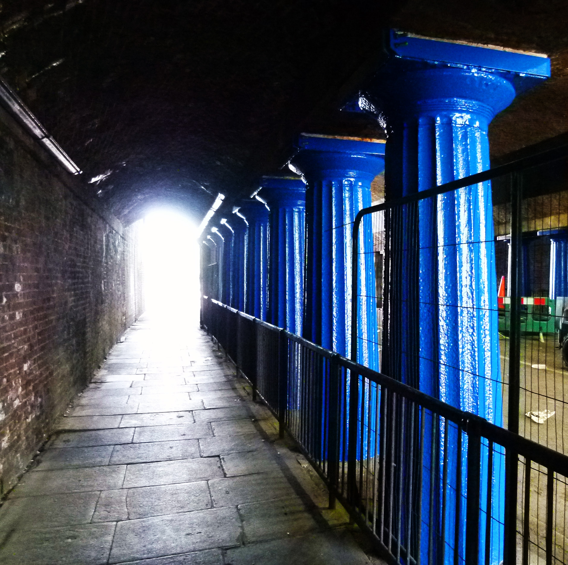
Ornate Doric columns beneath the viaduct on Abbey Street.
The viaduct also crosses Tower Bridge Road- at which point commuters can catch a glimpse of the famous, Thames crossing- and Druid Street; the site of another WWII calamity where, on October 25th 1940, the Druid Street arch- like that of Stainer Street- suffered a direct hit whilst packed with people seeking shelter.
77 people perished in the disaster.

Site of the Druid Street disaster.
Just across the road lies the St John’s Estate which runs parallel to the viaduct and where a faded sign indicating a WWII shelter can still be just about glimpsed.

Shelter sign on the St John’s Estate (image: Google Streetview).
Also located on Druid Street is the Alfred Salter playground, named after a kind hearted doctor who, along with his wife Ada, did much to help the impoverished people of Bermondsey during the early 20th century… despite the tragedy which struck their own lives.

Salter Park… the image in the corner is of Doctor Salter with his daughter, Joyce.
Please click here to read more about the Salters and their work.
*
Next door to the playground is the Downside Settlement; a pioneering youth club which has been open to local youngsters since 1908.
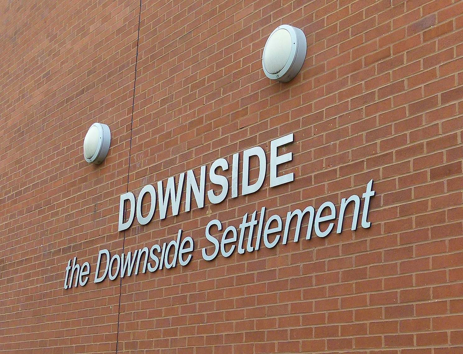
During the early 1980s, boxing matches staged at the club were televised on the fledgling Channel 4 in a show hosted by the late, great Henry Cooper.
*
Foul Times
Between Abbey Street and Crucifix Lane, the viaduct crosses Tanner Street- which was once known as Russell Street but has since been renamed as a reference to the leather trade which once thrived in the area.

Bermondsey’s old leather market, Weston Street (image: Google Streetview).
‘Tanning’ is the process in which animal skins are transformed into leather; a job which produces a notoriously foul stench due to the prescense of rotting flesh and the need for copious amounts of urine used to soak the hides.
Any scraps left over would be turned into glue; a process which produced further nasty odours.
In Victorian times especially, passengers chugging across the London to Greenwich viaduct would no doubt have been forced to close the windows as the train passed through the area.
*
It is perhaps no surprise that Bermondsey’s grim workhouse was plonked amongst the tanneries.
An 1860s map depicting the location of Bermondsey Workhouse.
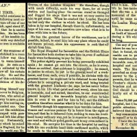
Even by workhouse standards, the accommodation for Bermondsey’s paupers was shocking.
This was vividly illustrated in the autumn of 1865 when The Lancet reported that the building’s basement often flooded to a depth of two feet and that the “accommodation of the wayfaring class, or ‘tramps’” was “not fit for a dog”; the bedding being improvised from orange crates with no straw to lie on and a “wooden log for a pillow.”

Admission ticket for the Bermondsey Workhouse (image via The Guardian).
The ward for those who were infirm also came in for scathing criticism, being described as:
“very dirty, and deficient in both light and air. The occupants were the most thoroughly ‘pauperized’ set we have seen in any of our visitations, herding together in a miserable manner in the midst of conditions which must render any medical treatment in their chronic diseases of little avail. Their watercloset and urinal (abutting on the deadhouse) stink so offensively as to poison the whole atmosphere…”
*
A Lost River
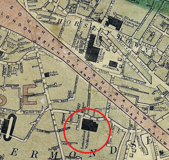
A little further up, the viaduct passes near a road which is simply known as ‘Neckinger’; the name of an old London river which is now channelled underground.
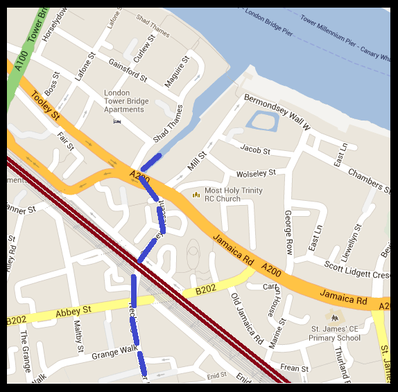
Map depicting the point where the railway viaduct crosses the subterranean Neckinger River (Map: Google).
‘Neckinger‘ is believed to derive from the term, ‘devil’s neck cloth’; a reference to the hangman’s noose- which is appropriate as pirates were often hung at St Saviour’s Dock where the river joins the Thames.
The area around St Saviour’s Dock (also known as ‘Jacob’s Island‘) featured in Charles Dickens’ Oliver Twist (originally published around the same period in which the London and Greenwich Railway opened) as the place where the vile Bill Sikes meets his untimely end (please click here to read more).

Bill Sikes- about to meet a nasty end near the mouth of the Thames…
*
Rouel Road… Stressed to Death?

Rouel Road (image: Google Streetview).
Rouel Road was once home to a boarding school which found itself at the centre of a rather bizarre case in October 1884, when it was reported in The Times that an 11 year old pupil; Master Adolphus James Davis died suddenly from alleged “over-pressure” from his studies.
Said to be “delirious”, young Adolphus “kept talking about his lessons, and repeating the words “I shall not pass” in allusion to an examination for which the school was preparing.
The coroner’s inquest into the death was held in the Bunch of Grapes pub on East Lane. In a statement which revealed much about conditions in the area at the time, schoolmaster, Seth Coward admitted that some pupils from the local area were “ill-clad and poorly fed” and that such “weak and delicate” boys “were expected to accomplish as much as the healthy and strong.”
Luckily for his teachers, it was agreed that Adolphus did not die from exam blues and a verdict of “death from apoplexy” was recorded.
Enid Street’s Communist Relic
Permanently parked on Enid Street as an advertising gimmick for one of the many garages which call the viaduct home, this little car is a ‘Trabant’; manufactured with little change in design between 1957 and 1990 in the former East Germany.

The Cold War comes to Enid Street…. an East German Trabant.
Often derided as being one of the worst cars ever made, the ‘Trabi’ as it was affectionately known was the most popular car in Eastern Germany- mainly of course because it was the only vehicle available to most of those living under the Communist regime.
In 1989, when the Berlin Wall finally tumbled, lots of these little cars were abandoned in the surge westwards.
Spa Road; Making London Transport History
When the London and Greenwich Railway first began serving the public in February 1836, the line was still very much under construction. The first working section to open was the stretch between Deptford and Spa Road… an arrangement which essentially made Spa Road the capital’s first ever railway terminus.

Plaque on Spa Road.
There have actually been two Spa Road stations. The first, which opened in the 1830s, was located near the junction with Rouel Road.

Spa Road Station in its earliest days. This drawing was made by Robert Blammell Schnebbelie; an artist who tragically died of starvation in 1849. (Image: Museum of London).
Built during an era when station design was still in its infancy, the original terminal was very basic indeed, consisting of two timber platforms connected to the street below by a rickety wooden staircase.
The ticket office was at street level and, as the image above illustrates, passengers were often required to queue on the stairwell whilst awaiting their train.
After the main terminal opened just over half a mile away at London Bridge, Spa Road’s passenger numbers suffered a significant decrease. In December 1838, it closed but opened again four years later following a refurbishment.
In 1872 the station underwent further change, moving 500 ft. south towards more substantial premises alongside Priter Way.

Spa Road Station in 1900 (image: Wikipedia).
The station ticked over until the outbreak of WWI when, faced with staff shortages and the on-going war emergency, Spa Road closed its doors for good on March 15th 1915, never to reopen again.
Dockley Road, beneath the derelict platforms…. the door seen on the right of this image was originally an entrance to Spa Road station.
Today, the ghost station sits quietly amongst a series of industrial units. Although closed to the public for nearly 100 years, the remnant still provides maintenance crews vital access to the tracks above.

The quiet remains of Spa Road Station…
The abandoned stairwells proved invaluable one night in January 1999 when two trains collided on the viaduct- the old Spa Road station being employed to evacuate over 200 stranded passengers to safety.